Global Agreement to Protect the Ocean Signed by 193 Nations

In a historic move, 193 nations came together in March 2023 to sign the United Nations (UN) High Seas Treaty, a landmark agreement that aims to protect the ocean and reverse biodiversity loss. The treaty, the first of its kind, establishes a framework for safeguarding the high seas, which make up two-thirds of the world’s ocean and fall beyond national boundaries and governance. The signing of this treaty signifies a growing recognition of the ocean’s importance and the need for its preservation.

UN Secretary-General António Guterres described the treaty as “crucial for addressing the triple threats of climate change, biodiversity loss, and pollution.” It is a significant step toward tackling these global challenges and promoting sustainable development. The ocean plays a vital role in mitigating climate change by generating 50 percent of the world’s oxygen, absorbing 25 percent of carbon dioxide emissions, and capturing 90 percent of excess heat caused by those emissions. Furthermore, it supports marine life and provides nearly 10 million tons of fish annually to feed a growing population.

Despite its immense value, the ocean remains largely unexplored and poorly understood. Until recently, only 6 percent of the Earth’s seafloor had been mapped to a comparable degree as the surface of the Earth, moon, or Mars. This lack of knowledge hampers efforts to protect marine ecosystems effectively. Approximately 91 percent of species in the ocean remain unclassified, highlighting the urgent need for comprehensive research and conservation efforts.

The ocean faces numerous threats, including rising temperatures, pollution, overfishing, and seabed mining. Over the past 30 years, ocean temperatures have increased due to rising concentrations of greenhouse gases, leading to sea-level rise, coastal land loss, and coastal flooding. The acidification of the ocean caused by higher carbon dioxide levels adversely affects marine species and ecosystems. Pollution from debris, including microplastics and abandoned fishing gear, continues to plague the ocean. Unsustainable fishing practices and commercial mining of seabed minerals further endanger marine life and the health of the ocean.

Recognizing the escalating threats to the ocean and its crucial role in sustaining the Earth, the UN declared 2021 to 2030 the United Nations Decade of Ocean Science for Sustainable Development (Ocean Decade). This ambitious plan aims to develop a better understanding of marine ecosystems, inform policy decisions, and promote sustainable management of the ocean. Esri, a leading technology company, is actively involved in several Ocean Decade programs and initiatives.

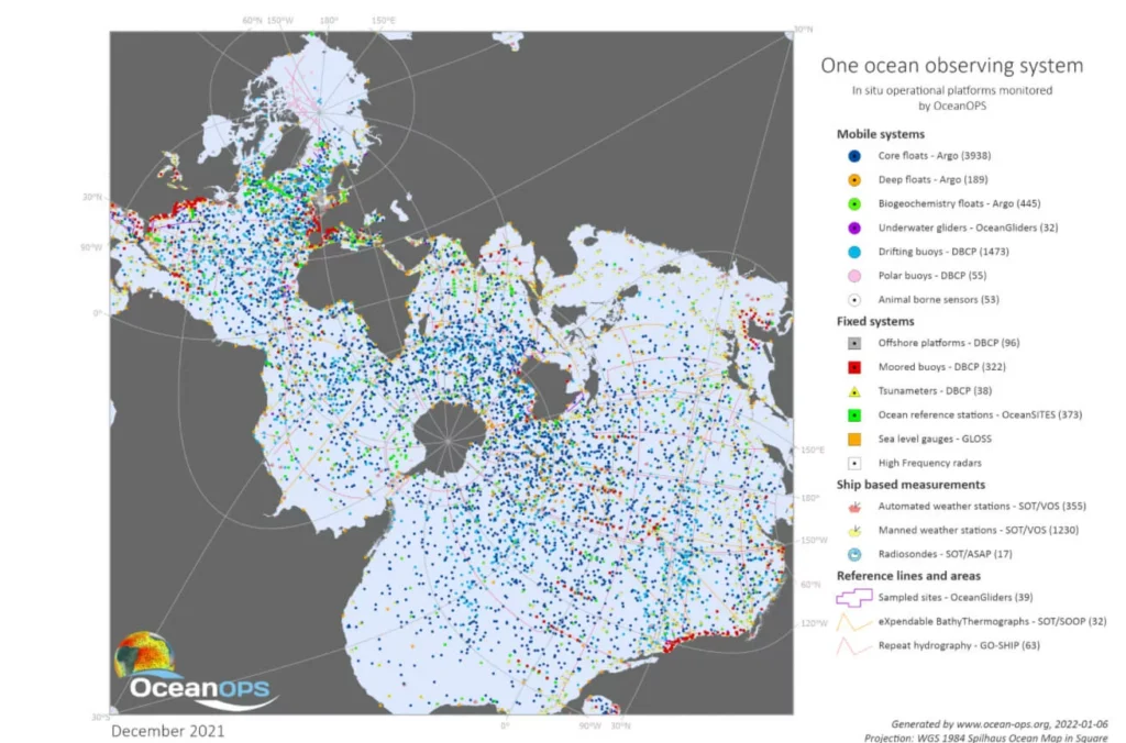
Esri’s participation in the Seabed 2030 project, a global initiative to map the entire ocean floor by 2030, is helping to expand the area of mapped seabed. Through partnerships and collaborations, Esri promotes the collection of bathymetric data and shares solutions for ocean mapping and data management. The company is also part of the Digital Twins of the Ocean (DITTO) program, which aims to create 3D digital ocean models using AI and specialized tools for marine data analysis.

In addition, Esri is involved in the Deep Ocean Observing Strategy (DOOS), an international organization coordinating the observation, exploration, and modeling of the deep ocean. By providing clear and engaging data visualizations through GIS, Esri helps tell the data stories and facilitates collaboration among scientists and policymakers. Esri’s commitment to ocean science and environmental protection extends to its work with the UN and other organizations, building the geospatial infrastructure necessary for addressing global challenges.

With its active involvement in various Ocean Decade programs, Esri demonstrates its dedication to scientific research, preservation of the ocean, and promoting sustainable practices. Through partnerships, technological advancements, and data-driven solutions, Esri continues to contribute to the understanding and protection of the ocean, ensuring a healthier

Harnessing GIS for Transparent Rental Housing in Beirut

The Beirut Urban Lab, a university research lab in Lebanon, has created an online platform called the City of Tenants to address the lack of transparency in the rental housing market in Beirut. The platform utilizes GIS technology to map rental information contributed by tenants, providing access to data on rent prices and neighborhood characteristics. The database, called the Beirut Built Environment, includes detailed information about the city’s infrastructure.

Through ArcGIS Survey123 and ArcGIS Experience Builder, tenants can anonymously contribute data on rental conditions, such as occupancy status and housing costs. The collected data is used by researchers and policymakers to understand urban trends and develop responsive public policies. The platform aims to empower tenants by providing them with readily available rental market data, helping them make informed decisions and negotiate more effectively. The Beirut Urban Lab plans to expand the platform to other cities in Lebanon and automate data updates through ArcGIS Survey123.

The Cartodyne GIS Team is Growing!

Cartodyne is looking to expand our growing team of GIS consultants as we look forward to 2021. We are looking for the two GIS roles described below. Pleases send a cover letter and resume to [email protected] to be considered for the role.

Who we are:

Cartodyne is a highly skilled Disaster Management and Information Technology services firm that leverages decades of industry practice with modern tools to deliver solutions for business organizations, cities, counties, and non-profits.

We believe that location intelligence is industry agnostic and applicable to most business and field operations. Coupled with modern cloud-based spatial solutions, Cartodyne provides world-class, remote-first or on-site operational GIS support with a reputation for quality and timely professional services.

What we seek:

We are looking for a mid-level GIS Consultant and Senior GIS Consultant.

Senior GIS Consultant
An enthusiastic and talented GIS practitioner capable of regular spatial project support activities, but also capable of skillfully creating GIS tools and applications when warranted. With 7 years of experience performing a similar role, you are intimately familiar with the Esri software stack on the desktop and in the cloud allowing you to configure ArcGIS Enterprise and write custom code.

Above all, you are a problem solver adept at deploying Enterprise GIS while designing and developing front-end and back-end application components & integrating with other internal systems and technologies. You can seamlessly coordinate with the team working to deliver interesting & challenging solutions. This role requires familiarity and related project experience within the Esri ecosystem while leveraging best practices in a dynamic environment.

GIS Consultant
An enthusiastic and capable GIS professional that will combine technical knowledge with business intelligence to enable GIS solutions aligned with business strategy. You have at least 3 years of escalating levels of responsibility that enables you to coordinate the analysis, design, deployment, administration, and configuration of complex GIS systems, databases, software, and equipment. You possess advanced knowledge of the Esri ecosystem including ArcGIS products, geodatabases, as well as spatial data processing and analysis.

Required capabilities:

Senior GIS Consultant

  • Develop and architect large scale GIS solutions using ESRI ArcGIS Portal, ArcGIS Desktop, ArcGIS Pro, ArcGIS Server, and ArcSDE GIS software to manipulate data in a raster and vector based geospatial environment.
  • Design, build, configure Esri Platform and apps using custom code (e.g. Python, JavaScript) or configurable platform apps.
  • Work closely with other developers and project team.
  • Understanding and working experience with solid application design principles.
  • Excellent communication and documentation skills.

GIS Consultant

  • Designs, develops, and maintains complex internal customer facing GIS Web applications through concept, design, and implementation phases to consume new web enabled GIS functionalities (using the latest relevant techniques and best practices).
  • Works with existing design templates to maintain corporate architecture and implementation standards.
  • Confirms accuracy of spatial data components of the centerline file, parcel polygons, other polygon datasets.
  • Works closely with client for the management, manipulation, and display of a wide variety of graphic and image data.

Required qualifications:

  • Bachelor’s Degree, in GIS , Computer Science, MIS, Business Administration or similar area of study. Three (3) years of previous experience required for GIS Consultant and seven (7) years of previous experience the Senior GIS Consultant role. An equivalent amount of related experience may substitute for the bachelor’s degree.
  • Three (3) or more years of relevant experience with geospatial development and technologies for the GIS Consultant and seven (7) years for the Senior GIS Consultant role.
  • US Citizenship.

You must be able to demonstrate familiarity with following during your technical interview:

Senior GIS Consultant
Esri software including ArcGIS Enterprise, Esri JavaScript API, Portal for ArcGIS, ArcGIS Desktop, ArcGIS Online, and their associated APIs or interfaces.

GIS Consultant
Esri software including ArcGIS Desktop, ArcGIS Pro, ArcCatalog, ModelBuilder, 3D Analyst/Spatial Analyst extensions.

Bonus points if you have:

  • Experience with Esri ArcGIS Enterprise 10.6 or higher.
  • Esri Developer Certification(s).
  • GISP Certification.
  • Hands-on experience with RESTful web services, distributed systems, and cloud computing.
  • Automating the Esri platform (e.g. Python scripting for AGO/Portal administration).
  • Working knowledge of SQL.
  • Hands-on experience with RESTful web services.
  • Understanding and working experience with version control systems (e.g. Git).

Cartodyne is committed to providing veteran employment opportunities to our service men and women.

The Company reserves the right to conduct a background check of its team members, and your employment may be conditioned on satisfactory results.

Pleases send a cover letter and resume to [email protected] to be considered for the role.