Cartodyne – Geospatial and Disaster Management Services

Cartodyne – Geospatial and Disaster Management Services

Cartodyne is a highly skilled Geospatial and Disaster Management services firm that leverages decades of industry practice with modern tools to deliver solutions for business organizations as well as local and state municipalities.

Menu

  • About Us
  • Our Approach
  • Services
  • News
  • Contact Us

3D Visualization in your web browser!

Glacier Point, Yosemite

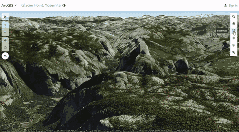
Glacier Point, Yosemite (Esri web scene)

Take a look at the web scene demo above created by Esri.

Web scenes are interactive displays of geographic information that are useful when you need to expose 3D data on the web for visualization and analysis.

Hint: This is best viewed on a tablet or laptop. If using a mouse, right click and drag.


cartodyne July 28, 2016March 11, 2021 Uncategorized
  • ← What is GIS? The Future of Smart
  • 2016 Summer Olympic Games – Story Map by Esri →

Contact

  • Email
    info@cartodyne.com
  • Phone
    281-213-0165
  • Address
    PO Box 833
    Spring, TX 77383

Copyright © 2022 Cartodyne

  • About Us
  • Our Approach
  • Services
  • News
  • Contact Us